

Real terrain, eighteen regions
Thermiker, a glider simulator that runs in the browser, flies eighteen real gliding regions. Fifteen are in Germany: Eschwege in Hesse, the Wasserkuppe in the Rhön, Unterwössen in the Chiemgau Alps, Königsdorf in the Bavarian Oberland, Bayreuth in Upper Franconia, Oerlinghausen in the Teutoburg Forest, Dümpel in the Bergisches Land, Celle-Scheuen on the Lüneburg Heath, Klippeneck, Laichingen and Aalen-Elchingen on the Swabian Jura, Lüsse in the Fläming, Grube on the Baltic coast of Ostholstein, Uetersen on the lower Elbe and Markdorf on Lake Constance. La Seu d'Urgell with the La Cerdanya gliding centre lies in the Spanish Pyrenees, Niederöblarn in the Ennstal in the Austrian Alps, and Schänis on the Linth in the Swiss Alps. All are built from official height data and aerial photos, with every building from OpenStreetMap standing in 3D, real tasks between real turnpoints, and weather set from ten summers of measured data. A third, generated landscape, the home valley, is where the training scenarios fly.
Europe magnified
- La Seu d'Urgell (LESU), Spain
- La Cerdanya (LECD), Spain
- Eschwege, Germany
- Wasserkuppe (EDER), Germany
- Aalen-Elchingen (EDPA), Germany
- Neresheim, Germany
- Bayreuth (EDQD), Germany
- Markdorf, Germany
- Dümpel (EDKF), Germany
- Grube (EDHB), Germany
- Klippeneck, Germany
- Königsdorf, Germany
- Ohlstadt, Germany
- Laichingen (EDPJ), Germany
- Hahnweide (EDST), Germany
- Schänis (LSZX), Switzerland
- Lüsse (EDOJ), Germany
- Niederöblarn (LOGO), Austria
- Oerlinghausen (EDLO), Germany
- Celle-Scheuen, Germany
- Uetersen (EDHE), Germany
- Unterwössen, Germany
More regions are coming. Which one should be next?
What "real terrain" means here
- Heights on a 25 m grid, averaged from survey data of 2 to 5 m. In the Pyrenees and in Thuringia that data comes from airborne laser scans. On the Hessian side of Eschwege, including the airfield, it comes from a satellite surface model corrected against the laser data, so it carries a few metres more error.
- Aerial photos streamed in as you fly: 4 m per pixel over the whole region, 2 m over the main valleys and ridges, 1 m around the airfield, and 0.5 m at the runway.
- Beyond the edge, mountains and plains continue more than 100 km to the horizon from coarser open data, so the view out is never cut off.
- Buildings, roads, rivers, lakes, power lines, masts and wind turbines from OpenStreetMap. Trees from land cover, by species.
- Fields you can land in: 810 charted fields around Eschwege and 143 around La Seu, each with a safe circuit and clear ground past its far end.
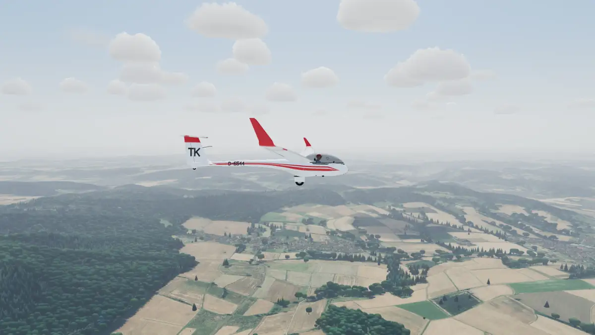
Eschwege (Werra-Meißner), Germany
A 40 x 40 km square centred on the gliding site Eschwege-Stauffenbühl in north-east Hesse, with the Werra valley, the Hoher Meißner (753 m), the Ringgau and about 40 % of the area in Thuringia.
- Airfield: Eschwege-Stauffenbühl, grass runway 02/20, 900 m long, about 260 m above sea level, with about 30 m of slope along the strip, as on the real field.
- Launches: winch, aerotow, or a start in the air.
- About 105,000 buildings, with half-timbered houses in the Hessian style.
- Weather: a classic Central European cumulus day by default. The cloud base follows ten summers of ERA5 data: about 1,300 m above the field at noon and 1,800 m at 15:00. Climbs of 1.5 to 2 m/s are typical.
- Ridge: in a stronger westerly the steep west slope of the Hoher Meißner works, about 1.5 m/s at 100 m over the slope in 30 km/h of wind, with sink behind the plateau. The Meißner is too small for more than a weak wave.
Tasks:
| Task | Length | Route |
|---|---|---|
| Meißner Triangle | 38 km | Hoher Meißner (Kasseler Kuppe), Bad Sooden-Allendorf |
| Werra Valley | 51 km | Bad Sooden-Allendorf, Wanfried, Treffurt |
| Ringgau and Meißner | 70 km | Bad Sooden-Allendorf, Hoher Meißner, Sontra, Heldrastein |
Wasserkuppe (Rhön), Germany
A 40 x 40 km square of the high Rhön around the Wasserkuppe (950 m), where gliding as a sport began in the 1920s: the famous west slope, the Pferdskopf, the Milseburg, the Lange Rhön and the Kreuzberg, across Hesse, Bavaria and a corner of Thuringia.
- Airfield: Wasserkuppe (EDER), asphalt runway 06/24, about 600 m, on the summit plateau at about 900 m. The runway drops 27 m from west to east, as on the real field.
- Launches: winch, aerotow, or a start in the air over the west slope.
- About 132,000 buildings.
- Weather: a classic Rhön summer day with a westerly. The cloud base follows ten summers of ERA5 data: about 2,200 m above sea level at 15:00, some 1,300 m over the summit.
- Ridge: the westerly blows straight up the west slope of the Wasserkuppe, about 1.3 m/s at 100 m over the slope in the default 18 km/h and over 2 m/s in 30 km/h, with sink in the lee over the Ulster valley.
Tasks:
| Task | Length | Route |
|---|---|---|
| Milseburg Triangle | 27 km | Milseburg, Simmelsberg |
| Milseburg and Kreuzberg | 41 km | Milseburg, Kreuzberg |
| Kreuzberg and Ellenbogen | 63 km | Milseburg, Kreuzberg, Ellenbogen |
La Seu d'Urgell and La Cerdanya, Pyrenees
A 64 x 48 km area of the Catalan Pyrenees: the Segre valley from Coll de Nargo to Puigcerda, the whole north face of the Serra del Cadi, Pedraforca, southern Andorra and the Cerdanya plain. Heights run from 515 m to 2,913 m.
Two start airfields:
- La Seu d'Urgell (LESU): asphalt runway 03/21, 1,267 m, at 800 m. In summer the valley wind blows up the Segre from the south-west, so runway 21 is in use.
- La Cerdanya (LECD): the gliding centre in the Cerdanya plain, 38 km east, asphalt runway 07/25, about 1,150 m, at 1,093 m. Hangars, club house, three windsocks, parked gliders and the tow plane. Fly from this airfield
Weather: a strong summer day by default, cloud base about 3,200 m above sea level and climbs of 2 to 3 m/s, higher over the high ground. The Wave day puts a gale across the Serra del Cadi: waves 6 to 10 km apart, up to 4 to 5 m/s, with lenticulars over the crests and a violent rotor below. Griffon vultures and kites circle in the thermals.
Tasks from La Seu d'Urgell:
| Task | Length | Route |
|---|---|---|
| Segre Valley | 47 km | Out and return to Martinet |
| Cadi and Segre | 65 km | Vulturo (Serra del Cadi), Bellver de Cerdanya |
| Pre-Pyrenees | 84 km | Organya, Pedraforca, Martinet |
| Cerdanya | 92 km | La Cerdanya airfield, Puigcerda, Monturull |
Tasks from La Cerdanya:
| Task | Length | Route |
|---|---|---|
| Cerdanya Triangle | 29 km | Puigcerda, Bellver de Cerdanya |
| Cadi Triangle | 47 km | Puigcerda, Comabona |
| Cadi and Cerdanya | 59 km | Puigcerda, Vulturo, Bellver de Cerdanya |
The turnpoints are towns, summits and airfields that pilots here use to find their way. The tasks are ours, not copied from a competition.
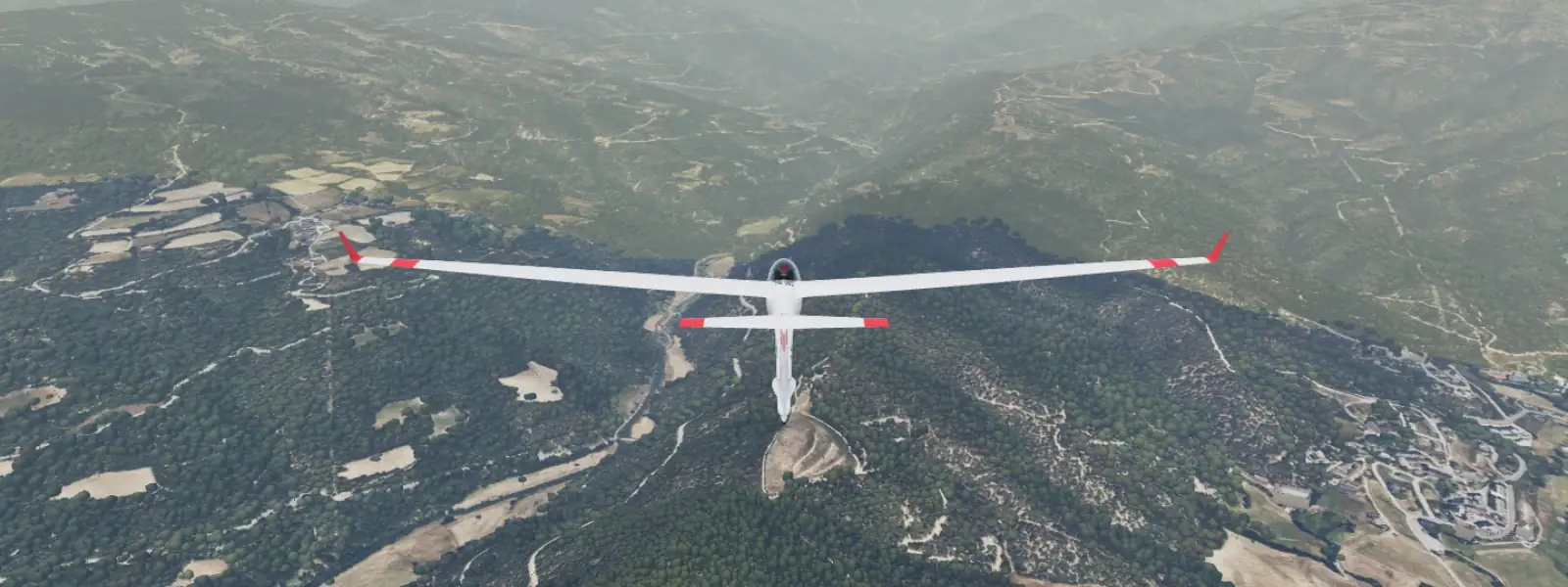
Aalen-Elchingen (Eastern Swabian Jura), Germany
A 40 x 40 km square of the eastern Swabian Jura around the Aalen-Elchingen airfield on the Härtsfeld plateau: the Albtrauf from Aalen past the Kapfenburg to the Ipf above Bopfingen, the Härtsfeld and the Albuch with the Volkmarsberg (743 m), the Brenz valley at Heidenheim, the Kocher and Jagst foreland up to Ellwangen, and the west rim of the Nördlinger Ries with Nördlingen.
- Airfield: Aalen-Elchingen (EDPA), the venue of many gliding championships. Gliders fly from the grass runway 09R/27L, about 910 m, beside the asphalt runway, at about 580 m on the plateau.
- Neresheim: the gliding field on the Härtsfeld above the Egau valley, grass runway 08/26, about 780 m, at 540 m. A second start field with its own card, 6 km south-east. Fly from this airfield
- Launches: winch, aerotow, or a start in the air.
- Heights from airborne laser scans and aerial photos at 20 cm from the surveys of Baden-Württemberg and Bavaria, over the whole square.
- Weather: a cumulus day with a light north-westerly by default. The cloud base follows ten summers of ERA5 data: about 2,400 m above sea level at 15:00.
- Ridge: in a north-westerly the Albtrauf above Aalen and the edge of the Härtsfeld above Bopfingen face the wind, 150 to 250 m over the foreland: about 1 m/s at 100 m over the slope in the default 12 km/h, more than 2 m/s in 30 km/h. Neresheim, Bopfingen, Nördlingen, Giengen, Steinheim, Ellwangen and Bartholomä are on the outlanding chart.
Tasks:
| Task | Length | Route |
|---|---|---|
| Ipf-Braunenberg | 43 km | Ipf, Braunenberg |
| Nördlingen-Volkmarsberg | 62 km | Nördlingen, Volkmarsberg |
| Heidenheim-Ipf-Nördlingen | 80 km | Heidenheim, Braunenberg, Ipf, Nördlingen |
| Neresheim-Ipf-Volkmarsberg (from Neresheim) | 55 km | Ipf, Volkmarsberg |
Bayreuth (Upper Franconia), Germany
A 42 x 42 km square of Upper Franconia around Bayreuth, a classic competition site: the Fichtelgebirge in the east with the Ochsenkopf (1,024 m) and the Schneeberg (1,051 m), the Red Main valley and Bayreuth itself, the Franconian Jura edge from Kulmbach to the Hummelgau, and the north of Franconian Switzerland. All of it in Bavaria, with Bavarian laser heights and summer photos.
- Airfield: Bayreuth (EDQD) on the Bindlacher Berg at 488 m, asphalt runway 06/24 of about 1,000 m, with the glider grass strips beside it.
- Launches: winch, aerotow, or a start in the air over the fields west of the field.
- About 145,000 buildings.
- Weather: a classic Upper Franconian summer day with a light westerly. The cloud base follows eleven summers of ERA5 data: about 2,350 m above sea level at 15:00, some 1,850 m over the field.
- Ridge: in a westerly gale the west slopes of the Ochsenkopf and the Schneeberg carry, about 1.3 m/s at 100 m over the slope in 30 km/h, with strong sink in their lee.
Tasks:
| Task | Length | Route |
|---|---|---|
| Ochsenkopf Triangle | 39 km | Ochsenkopf, Bayreuth |
| Neubürg and Ochsenkopf | 66 km | Neubürg, Ochsenkopf |
| Neubürg, Kulmbach and Schneeberg | 94 km | Neubürg, Kulmbach airfield, Schneeberg |
Bodensee (Markdorf), Lake Constance in Germany, Switzerland and Austria
A box of 40 x 45.5 km around the glider field Markdorf in the Linzgau on the German shore of Lake Constance: the Obersee in the middle, the hills of the Linzgau and the Gehrenberg to the north, the Swiss shore with the Appenzell hills to the south-west, and the Rhine valley with Hohenems, Dornbirn and Bregenz in Austria to the south-east. The first region with three countries: heights from the swisstopo, Baden-Württemberg and Bavaria laser models and, in Vorarlberg, the Copernicus model, with aerial photos from all four and one flat lake surface at 395 m across the borders.
- Airfields: Markdorf, a 930 m grass strip of the Segelfliegergruppe Markdorf, as the start field. Friedrichshafen (EDNY), St. Gallen-Altenrhein (LSZR), Hohenems-Dornbirn (LOIH) and Sitterdorf (LSZV) are on the chart as landing fields.
- Launches: winch, aerotow, or a start in the air over the field.
- Weather: a summer day with light north-east wind and cloud base about 2,100 m above sea level, from ten summers of ERA5 data.
- Landscape: the Linzgau hills carry the first thermals; the Swiss and Austrian hills on the far shore and the foot of the Pfänder are the next targets. Friedrichshafen and Altenrhein have controlled airspace that is not in the game.
Tasks:
| Task | Length | Route |
|---|---|---|
| Linzgau Triangle | 42 km | Grünkraut, Gehrenberg |
| Gehrenberg Circuit | 58 km | Gehrenberg, Neukirch, Grünkraut |
| Bodensee Round | 81 km | Gehrenberg, Neukirch, Lindau, Arbon |
Dümpel (Bergisches Land), Germany
A 48.5 x 40 km box around the Dümpel gliding site in the Oberberg, North Rhine-Westphalia: the wooded ridges and deep valleys of the Bergisches Land, the Ebbegebirge with the Nordhelle, and the edge of the Sauerland.
- Airfield: Dümpel (EDKF), a 600 m grass strip on a hilltop at about 488 m, run by the Luftsport-Club Dümpel. The north-east (22) end sits 6 m higher than the south-west (04) end, so take-off on 22 runs downhill into the usual wind.
- Launches: winch, aerotow, or a start in the air over the slope.
- Outlanding fields: Wipperfürth-Neye (EDKN) and the Lindlar glider field, 23 km west of the home field, are on the chart.
- Weather: a classic summer day with a west-south-westerly by default. The cloud base follows ten summers of ERA5 data: about 2,100 m above sea level at 15:00, some 1,600 m over the field.
- Ridge: in a fresh westerly the wind-facing slopes of the Oberberg hills give modest ridge lift; the relief stands 150 to 250 m over the valleys.
Tasks:
| Task | Length | Route |
|---|---|---|
| Nordhelle Triangle | 31 km | Nordhelle, Drolshagen |
| Sauerland Circuit | 43 km | Olpe, Attendorn, Nordhelle |
| Oberberg Tour | 66 km | Attendorn, Gummersbach, Reichshof |
Grube (Ostholstein), Germany
A 40 x 40 km square on the Baltic coast of Schleswig-Holstein, around the club field Grube: the rolling moraine land of Wagrien with fields, hedgerows and beech woods, the Bungsberg at 168 m, the lakes of the Holstein Switzerland near Malente and Eutin, and the coast from Heiligenhafen to Neustadt. Over a third of the square is open sea.
- Airfield: Grube (EDHB), grass gliding strip 09/27, about 930 m, beside the powered runway, at 2 m above sea level in the low ground of the Oldenburger Graben.
- Launches: winch, aerotow, or a start in the air over the field.
- About 76,000 buildings and 213 wind turbines. Sierksdorf/Hof Altona, 23 km south-west, is the next airfield.
- Weather: a summer day on the coast with a light easterly from the sea. The sea air keeps the cloud base low: 1,400 m above sea level.
- Thermals: over the dry fields and villages inland; the wet meadows of the graben and the sea give little. No ridge.
Tasks:
| Task | Length | Route |
|---|---|---|
| Bungsberg Triangle | 49 km | Bungsberg, Grömitz |
| Wagrien Tour | 59 km | Oldenburg, Bungsberg, Neustadt |
| Ostholstein Tour | 99 km | Heiligenhafen, Oldenburg, Lütjenburg, Malente, Neustadt, Grömitz |
Klippeneck (Swabian Jura), Germany
A 40 x 40 km square of the Swabian Jura around the gliding site Klippeneck, on the edge of the Albtrauf near Spaichingen: the escarpment from the Dreifaltigkeitsberg past the Lemberg (1,015 m) to the Plettenberg, the Heuberg plateau behind it and the Neckar land with Rottweil in front of it.
- Airfield: Klippeneck, grass runway 05/23, about 750 m, at about 960 m on the plateau, a few hundred metres from the edge. The strip drops about 15 m to the north-east, as on the real field.
- Launches: winch, aerotow, or a start in the air over the Albtrauf.
- Heights from airborne laser scans and aerial photos at 20 cm from the Baden-Württemberg survey, over the whole square.
- Weather: a westerly ridge day by default, wind across the edge. The cloud base follows ten summers of ERA5 data: about 2,600 m above sea level at 15:00.
- Ridge: in a westerly the Albtrauf carries along its whole length, 200 to 300 m high, with the field on top of it: about 1.5 m/s at 100 m over the slope in the default 20 km/h, over 2 m/s in 30 km/h. Neuhausen ob Eck, Rottweil-Zepfenhan, Schwenningen and Donaueschingen are on the outlanding chart.
Tasks:
| Task | Length | Route |
|---|---|---|
| Lemberg-Plettenberg | 25 km | Lemberg, Plettenberg |
| Plettenberg-Lupfen | 47 km | Plettenberg, Lupfen |
| Lochenstein-Neuhausen-Lupfen | 71 km | Lochenstein, Neuhausen ob Eck airfield, Lupfen |
Königsdorf (Bavarian Oberland), Germany
A 40 x 40 km square of the Bavarian Oberland around the Segelflugzentrum Königsdorf, one of the big gliding centres south of Munich: the Isar and Loisach valleys, the Kochelsee and the Walchensee, and the first Alpine ridges from the Blomberg past the Brauneck and the Benediktenwand to the Herzogstand and the Heimgarten. Heights run from 540 m in the Isar valley to 1,840 m.
- Airfield: Königsdorf, runway 10/28, about 785 m, at 600 m in the open foreland. Take-off on 10, into the light north-easterly of a summer soaring day.
- Ohlstadt: the gliding centre in the Loisach valley under the Heimgarten, asphalt runway 04/22, about 880 m, at 660 m. A second start field with its own card, right at the Alpine edge. Fly from this airfield
- Launches: winch, aerotow, or a start in the air.
- Heights from airborne laser scans and aerial photos at 20 cm from the Bavarian survey.
- Weather: a cumulus day with a light north-easterly by default. The cloud base follows ten summers of ERA5 data: about 2,300 m above sea level at 15:00.
- Ridge: in a northerly the north faces of the Benediktenwand, the Brauneck and the Herzogstand stand in the wind, 1,000 m over the foreland. On a foehn day the wind blows from the south across the Alps and lee waves stand over the foreland. Benediktbeuern and Greiling are on the outlanding chart.
Tasks:
| Task | Length | Route |
|---|---|---|
| Blomberg-Benediktenwand | 39 km | Blomberg, Benediktenwand |
| Brauneck-Herzogstand-Penzberg | 63 km | Brauneck, Herzogstand, Penzberg |
| Seekarkreuz-Heimgarten-Murnau | 88 km | Blomberg, Seekarkreuz, Heimgarten, Murnau |
| Herzogstand-Benediktenwand (from Ohlstadt) | 48 km | Herzogstand, Benediktenwand, Penzberg |
Laichingen (Swabian Jura), Germany
A 40 x 40 km square of the Swabian Jura around the Jakob-Laur-Flugplatz Laichingen on the high Alb plateau: the Albtrauf from Neuffen past the Teck and Wiesensteig to Geislingen, the plateau with the Römerstein (874 m) and the Blau valley at Blaubeuren, and the foreland of the Neckar and the Fils in front of the edge.
- Airfield: Laichingen (EDPJ), runway 07/25, about 920 m with 500 m of asphalt in the middle, at about 740 m on the plateau.
- Hahnweide (EDST): the big gliding field at the foot of the Albtrauf near Kirchheim unter Teck, grass runway 12/30, about 630 m, at 350 m. A second start field with its own card, under the Teck. Fly from this airfield
- Launches: winch, aerotow, or a start in the air.
- Heights from airborne laser scans and aerial photos at 20 cm from the Baden-Württemberg survey, over the whole square.
- Weather: a cumulus day with a light north-westerly by default. The cloud base follows ten summers of ERA5 data: about 2,500 m above sea level at 15:00.
- Ridge: in a north-westerly the Albtrauf faces the wind, 300 to 450 m over the foreland: about 2 m/s at 100 m over the slope below the Boßler in the default 15 km/h. Blaubeuren, Grabenstetten, Gruibingen-Nortel, Berneck, Oppingen, Hülben and Nabern are on the outlanding chart.
Tasks:
| Task | Length | Route |
|---|---|---|
| Römerstein-Kornberg | 35 km | Römerstein, Kornberg |
| Kornberg-Schildwacht-Blaubeuren | 65 km | Kornberg, Schildwacht, Blaubeuren |
| Schachen-Schildwacht | 86 km | Schachen, Römerstein, Kornberg, Schildwacht |
| Hahnweide-Römerstein (from the Hahnweide) | 45 km | Römerstein, Kornberg |
Linth (Schänis), Switzerland
A 40 x 40 km square around the gliding airfield Schänis (LSZX) on the Linth plain in eastern Switzerland, the first Swiss region: the Walensee and the Glarus Alps to the south, the Speer and the Churfirsten to the east, the upper end of Lake Zurich to the west, with heights from the swisstopo laser terrain model and the SWISSIMAGE aerial photo. The land runs from 405 m at the lakes to the 2,900 m summits of the Glarus Alps.
- Airfields: Schänis (LSZX), a 520 m asphalt strip on the Linth plain and home of the Alpine Segelflugschule Schänis, as the start field. Wangen-Lachen (LSPV) and Mollis are on the chart as landing fields.
- Launches: aerotow, or a start in the air over the plain.
- Weather: a good Alpine summer day by default, cloud base about 2,500 m above sea level, with light wind from the north-east. Thermals are stronger than in the lowlands.
- Mountains: fly the sunny south faces of the Federispitz, the Speer and the Mattstock, then follow the Walensee towards the Churfirsten, with the plain always below for landing.
Tasks:
| Task | Length | Route |
|---|---|---|
| Speer Triangle | 34 km | Wattwil, Speer |
| Linth Circuit | 42 km | Lachen, Näfels |
| Glarus Alps | 69 km | Lachen, Glarus, Murg, Speer |
Lüsse (Fläming), Germany
A 40 x 40 km square of the Fläming in Brandenburg around Lüsse, a club field known for long cross-country flights over flat land: fields and pine heath, the Hoher Fläming with the Hagelberg (200 m) near Bad Belzig, and the Havel lakes in the north.
- Airfield: Lüsse (EDOJ), grass runway 06/24, about 1,000 m, at 65 m above sea level, with long winch runs beside it.
- Launches: winch, aerotow, or a start in the air over the field.
- About 117,000 buildings and 124 wind turbines.
- Weather: a classic summer day in the Fläming with a light westerly. The cloud base follows ten summers of ERA5 data: about 2,050 m above sea level at 15:00, nearly 2,000 m over the field.
- Thermals: over the fields and the sandy heath, with the pine woods as triggers. No ridge: the Hoher Fläming is too gentle to carry a glider.
Tasks:
| Task | Length | Route |
|---|---|---|
| Hagelberg Triangle | 36 km | Hagelberg, Brück |
| Fläming and Zauche | 59 km | Wiesenburg, Golzow, Brück |
| Fläming Grand Tour | 104 km | Treuenbrietzen, Rädigke, Wiesenburg, Wollin, Lehnin |
Niederöblarn (Ennstal), Austria
A 40 x 40 km square around the gliding airfield Niederöblarn (LOGO) in the Styrian Ennstal, the first Austrian region and the first high-mountain valley in Thermiker: the Grimming (2,351 m) and the Dachstein massif to the north, the Niedere Tauern with their 2,500 m summits to the south, and the flat valley floor of the Enns at about 650 m.
- Airfield: Niederöblarn (LOGO), a 730 m asphalt strip on the valley floor, home of the Alpenflugschule and a championship site.
- Launches: aerotow, winch, or a start in the air over the valley.
- Weather: a strong inner-Alpine summer day by default, cloud base about 2,800 m above sea level, some 2,150 m over the valley floor. Thermals are stronger than in the lowlands.
- Mountains: fly the sunny south faces of the Grimming and the Tauern ridges, with the valley always below for landing.
Tasks:
| Task | Length | Route |
|---|---|---|
| Grimming | 32 km | Pruggern, Grimming |
| Ennstal | 43 km | Stainach, Pruggern |
| Grimming and Tauern | 55 km | Weißenbach, Grimming, Stainach |
Oerlinghausen (Teutoburg Forest), Germany
A 40 x 40 km square around Oerlinghausen in North Rhine-Westphalia, the largest gliding site in Europe: the ridge of the Teutoburg Forest from Bielefeld past the Hermann monument to the Externsteine, the Senne heath in front of it and the Lippe hills behind it.
- Airfield: Oerlinghausen (EDLO), a wide grass field with five winch lanes and a landing strip of about 1,200 m, at about 170 m above sea level. The field rises 25 m towards the ridge, as on the real one.
- Launches: winch, aerotow, or a start in the air over the ridge.
- About 475,000 buildings, with Bielefeld at the north-west end of the ridge.
- Weather: a classic summer day with a south-westerly by default. The cloud base follows ten summers of ERA5 data: about 2,000 m above sea level at 15:00, some 1,800 m over the field.
- Ridge: a south-westerly blows up the south face of the Teutoburg Forest, about 1.1 m/s at 100 m over the slope in the default 15 km/h and over 2 m/s in 30 km/h, with sink behind the ridge.
Tasks:
| Task | Length | Route |
|---|---|---|
| Hermann Triangle | 33 km | Hermannsdenkmal, Lage |
| Teutoburg Ridge | 50 km | Hermannsdenkmal, Bielefeld |
| Lippe Tour | 65 km | Hermannsdenkmal, Lemgo, Bielefeld |
Celle-Scheuen (Lüneburg Heath), Germany
A 40 x 40 km square on the southern edge of the Lüneburg Heath near Celle, Lower Saxony: the Aller valley, pine heath and open farmland. Flat country, thermal soaring without a ridge, like Lüsse in Brandenburg.
- Airfield: Celle-Scheuen, a grass gliding field at about 54 m. A single east-west winch axis of about 1.1 km, matching the club's winch cable; the strip is nearly level.
- Launches: winch, aerotow, or a start in the air over the fields.
- Weather: a classic summer day with a west-south-westerly by default. The cloud base follows ten summers of ERA5 data: about 1,950 m above sea level at 15:00.
- No ridge: the lift is thermal. The heath's dry pine and sandy fields trigger well on a sunny afternoon.
Tasks:
| Task | Length | Route |
|---|---|---|
| Celle Triangle | 33 km | Celle, Eschede |
| Aller Circuit | 53 km | Eschede, Winsen (Aller), Celle |
| Heath Tour | 59 km | Eschede, Bergen, Celle |
Uetersen (Elbe), Germany
A 40 x 40 km square of Schleswig-Holstein north-west of Hamburg, around the club field Uetersen-Heist: the Elbe marsh from Wedel to Glückstadt with its long, ditch-lined meadows, the Geest with hedgerows and woods around Elmshorn, Pinneberg and Barmstedt, and the north-west edge of Hamburg.
- Airfield: Uetersen-Heist (EDHE), grass gliding strip 09/27, about 1,200 m, beside the powered runway, at 7 m above sea level.
- Launches: winch, aerotow, or a start in the air over the field.
- About 284,000 buildings and 136 wind turbines. Ahrenlohe, 6 km north, is the next airfield.
- Weather: a classic summer day on the lower Elbe with a light westerly. The cloud base follows ten summers of ERA5 data: about 1,550 m above sea level at 15:00.
- Thermals: over the dry Geest fields and the villages; the wet marsh and the river work less well. No ridge.
Tasks:
| Task | Length | Route |
|---|---|---|
| Geest Triangle | 44 km | Quickborn, Barmstedt |
| Elbe Marsh | 67 km | Elmshorn, Glückstadt, Barmstedt |
| Steinburg Tour | 96 km | Kaltenkirchen, Lägerdorf, Glückstadt, Elmshorn |
Unterwössen (Chiemgau), Germany
A 40 x 40 km square of the Chiemgau Alps around Unterwössen, the home of the German Alpine Gliding School: the Achental from Grassau to Kössen, the Hochgern, the Hochfelln, the Kampenwand, the Geigelstein and the Rauschberg above Ruhpolding, with the Chiemsee to the north and the Kaiserwinkl of Tyrol to the south. Heights run from 460 m at the lake to almost 2,000 m.
- Airfield: Unterwössen, asphalt runway 06/24, about 800 m, in the valley floor at about 556 m. In the afternoon the valley wind blows up the Achental from the north-east, so runway 06 is in use.
- Launches: winch, aerotow, or a start in the air over the valley.
- About 106,000 buildings.
- Weather: a classic Chiemgau summer day with a light westerly. The cloud base follows ten summers of ERA5 data: about 2,350 m above sea level at 15:00, some 1,800 m over the field.
- Terrain: Bavarian laser heights and summer orthophotos; the Tyrolean strip has satellite heights and imagery.
Tasks:
| Task | Length | Route |
|---|---|---|
| Hochfelln-Kampenwand | 31 km | Hochfelln, Kampenwand |
| Geigelstein-Rauschberg | 53 km | Geigelstein, Rauschberg |
| Hochries-Rauschberg-Unterberghorn | 82 km | Hochries, Rauschberg, Unterberghorn |
The home valley
A generated valley with a long ridge east of the field, a lake and a grass runway. The scenarios fly here: cable break, field landing, ridge run and the daily final glide. Its own tasks run along the windward ridge: Valley Triangle (30 km), Ridge Run (39 km) and Double Ridge Run (62 km).
Which region for what
- First flights and the lessons: Eschwege. Gentle hills, a grass strip, plenty of fields.
- Slope soaring where it all began: the Wasserkuppe.
- Ridge flying on a long edge: Klippeneck, where the Albtrauf carries along its whole length, and Oerlinghausen, along the Teutoburg Forest.
- Alpine valleys and big hills: Unterwössen in the Chiemgau Alps, and Bayreuth with the Fichtelgebirge.
- Alps foreland and the first ridges of the Alps: Königsdorf and Ohlstadt, with the Isar and Loisach valleys.
- The Swabian Jura: the Albtrauf at Laichingen and the Hahnweide, and the Härtsfeld at Aalen-Elchingen and Neresheim.
- Long cross-country over flat land: Lüsse in the Fläming, with a task of 100 km.
- Mountain soaring, ridge and wave: La Seu d'Urgell and La Cerdanya.
- Flat land by the water: Grube on the Baltic coast and Uetersen on the lower Elbe.
- Drills: the home valley.
Data and credits
Heights and photos come from the Instituto Geografico Nacional (Spain), the Institut Cartografic i Geologic de Catalunya, IGN France, the Thuringian state survey (GDI-Th), the Bavarian survey (Bayerische Vermessungsverwaltung), the Hessian survey (HVBG), the surveys of North Rhine-Westphalia (Geobasis NRW), Baden-Württemberg (LGL) and Brandenburg (LGB), Copernicus and EOX Sentinel-2 cloudless, buildings and roads from OpenStreetMap contributors, weather statistics from ERA5 (Copernicus Climate Change Service). All under licences that allow this use, credited in full in the game under Credits.
More regions
More regions are planned, German gliding sites first. We will name them here when they fly, not before.
Related
- How thermals work: ridge lift and wave explained.
- Gliders: which glider for which region.
- Find a gliding club: clubs near Eschwege and elsewhere.